


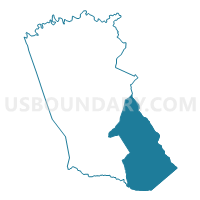
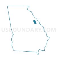
189133B - DEARING GYM Voting District, McDuffie County, Georgia
About
Outline

Summary
| Unique Area Identifier | 562435 |
| Name | 189133B - DEARING GYM Voting District |
| County | McDuffie County |
| State | Georgia |
| Area (square miles) | 55.31 |
| Land Area (square miles) | 54.66 |
| Water Area (square miles) | 0.65 |
| % of Land Area | 98.83 |
| % of Water Area | 1.17 |
| Latitude of the Internal Point | 33.39189600 |
| Longtitude of the Internal Point | -82.37563780 |
Maps

Graphs
Select a template below for downloading or customizing gragh for 189133B - DEARING GYM Voting District, McDuffie County, Georgia


Neighbors
Neighoring Voting District (by Name) Neighboring Voting District on the Map
- 073020 - HARLEM MIDDLE SCHOOL Voting District, Columbia County, GA
- 073021 - HARLEM BAPTIST Voting District, Columbia County, GA
- 073025 - BESSIE THOMAS Voting District, Columbia County, GA
- 1630081 - WRENS Voting District, Jefferson County, GA
- 189133A - FORT CREEK Voting District, McDuffie County, GA
- 189135 - SALEM ROAD Voting District, McDuffie County, GA
- 189137 - MARSHALL CHURCH Voting District, McDuffie County, GA
- 189138 - SHRINE Voting District, McDuffie County, GA
- 189139 - WHITEOAK Voting District, McDuffie County, GA
- 245803 - 803 Voting District, Richmond County, GA
- 3016 - PAN HANDLE Voting District, Warren County, GA
Top 10 Neighboring County Subdivision (by Population) Neighboring County Subdivision on the Map
- Grovetown-Harlem CCD, Columbia County, GA (26,306)
- Thomson CCD, McDuffie County, GA (16,615)
- Fort Gordon CCD, Richmond County, GA (8,992)
- Dearing CCD, McDuffie County, GA (5,260)
- Wrens CCD, Jefferson County, GA (5,179)
- Panhandle CCD, Warren County, GA (175)
Top 10 Neighboring Place (by Population) Neighboring Place on the Map
- Augusta-Richmond County consolidated government (balance), GA (195,844)
- Harlem city, GA (2,666)
- Dearing town, GA (549)
Top 10 Neighboring Unified School District (by Population) Neighboring Unified School District on the Map
- Richmond County School District, GA (200,549)
- Columbia County School District, GA (124,053)
- Mcduffie County School District, GA (21,875)
- Jefferson County School District, GA (16,930)
- Warren County School District, GA (5,834)
Top 10 Neighboring State Legislative District Lower Chamber (by Population) Neighboring State Legislative District Lower Chamber on the Map
- State House District 117, GA (64,224)
- State House District 123, GA (49,250)
- State House District 124, GA (45,898)
- State House District 142, GA (45,637)
Top 10 Neighboring State Legislative District Upper Chamber (by Population) Neighboring State Legislative District Upper Chamber on the Map
Top 10 Neighboring 111th Congressional District (by Population) Neighboring 111th Congressional District on the Map
Top 10 Neighboring Census Tract (by Population) Neighboring Census Tract on the Map
- Census Tract 108, Richmond County, GA (8,992)
- Census Tract 305.03, Columbia County, GA (6,751)
- Census Tract 9504, McDuffie County, GA (5,805)
- Census Tract 9502, McDuffie County, GA (5,382)
- Census Tract 9505, McDuffie County, GA (5,260)
- Census Tract 9601, Jefferson County, GA (5,179)
- Census Tract 305.04, Columbia County, GA (3,371)
- Census Tract 9704, Warren County, GA (2,846)